This is the county in which the deer was harvested. Required field
Date in which the deer was harvested. Required field Must be in the format mm/dd/yyyy and cannot be greater
than the current date.
Antlered is defined as deer with bare antlers visible above the natural hairline. Unantlered is defined as deer without bony antlers visible above the natural hairline. Required field
The legal arms used to harvest a deer. The "Pre-charged Air Rifle" indicates the pre-charged pneumatic arrow shooting rifle. Required field.
A female is called a doe and a male is called a buck Required field.
A point is defined as an antler projection of at least one inch in length from base to tip. Enter the total number of points for each antler. Required field
How to measure points
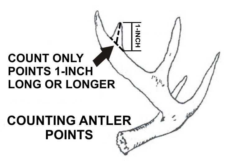
How to measure points
The landownership type of the location in which the deer was harvested. Private includes land that is leased or owned.
WMA (Wildlife Management Area) is land that is managed by DCNR Division of Wildlife.
Forever Wild is land managed by DCNR State Lands Division that includes Forever Wild Land Trust Nature Preserves and Recreation Areas with hunting
provisions that are not within the WMA system.
State Park is land managed by DCNR State Parks Division with hunting provisions.
Special Opportunity Area (SOA) is land managed by DCNR Division of Wildlife for special permit limited quota hunts.
PDHA (Physically Disabled Hunting Area) is land managed by DCNR that has hunting provisions for individuals with physical disabilities.
Federal includes lands that are owned or managed by a federal entity including US Forest Service, National Wildlife
Refuge, US Army Corps of Engineers, Tennessee Valley Authority (TVA), and Department of Defense Lands with provisions for hunting.
Other Public includes public land that is not managed or owned by a DCNR or Federal entity.
Required field
The specific public property in which the deer was harvested. The specific harvest location is only requested for public landownerships types
that are managed or owned by DCNR or Federal entity (see Help for Harvest Location Landowner for description of DCNR and Federal entities).
The selection list is restricted to Public lands with hunting provisions and limited by the hunter’s selection of County of Harvest and
Harvest Location Landowner.
Required field
HRZ | High Risk Zone (Area in Lauderdale County west of U.S. Highway 43)
BZ | Buffer Zone (Area in Lauderdale County east of U.S. Highway 43 and all of Colbert County)
HRZ - CWD Permit | High Risk Zone with CWD Sampling Permit
BZ - CWD Permit | Buffer Zone with CWD Sampling Permit
Required field
BZ | Buffer Zone (Area in Lauderdale County east of U.S. Highway 43 and all of Colbert County)
HRZ - CWD Permit | High Risk Zone with CWD Sampling Permit
BZ - CWD Permit | Buffer Zone with CWD Sampling Permit
Required field